Single digit temps and wind chill
Jefferson Co. EMA is monitoring another Winter Storm again this weekend. Here is the latest from our friends at the National Weather Service’s Office in Louisville.
***
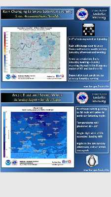
Moderate to heavy rain is still expected to spread across central Kentucky and southern Indiana on Saturday, with totals between 1-2 inches. An arctic front sweeping through the region will change the rain over to snow during the late afternoon and evening hours of Saturday.
Minor snow accumulations are likely Saturday evening through early Sunday, with the highest amounts in southern Indiana and north-central Kentucky. Roads will likely become slick Saturday night.
Strong north winds will spread arctic air into the region Saturday night. Temperatures will plummet 20-30 degrees from daytime highs. Wind chills will drop into the single digits.
Authority: NWS Louisville
 Gov. Beshear Demands Sen. McConnell Provide 'Proof of Capacity to Serve'
 South Ripley Community School Corporation Superintendent Named 2027 Indiana Superintendent of the Year
 Save the Date: Swiss Wine Festival is Almost Here